Access to palliative care in India: situational analysis and modeling of access from public healthcare centers
Parth Sharma1,2†, Harsh Thakkar1†, Aryan Patil1, Preeti Chauhan3, Priya Chembon3, Shalini Arora Joseph3, Smriti Rana4, Raj Kalady3, Vidhi Wadhwani1, Gaurav Urs1, Padmavathy Krishna1, Rontu Sangma3, Rajendra Dutt Bijalwan3, Sunanda Samal3, Lalit Selvaraju3, Syed Mohammad Askari Naqvi3, Jatin Bhukal3, Johnsurya John3, Muttacaud Ramakrishnan Rajagopal3 and Siddhesh Zadey1
1Association for Socially Applicable Research (ASAR), Pune, Maharashtra 411007, India
2Department of Community Medicine, Maulana Azad Medical College, New Delhi 110002, India
3Pallium India, Thiruvananthapuram, Kerala 695011, India
4WHO Collaborating Centre for Training and Policy on Access to Pain Relief, Thiruvananthapuram, Kerala 695011, India
†Contributed equally
Abstract
Background: Nearly 7–10 million people require palliative care (PC) in India, with less than 4% having access to it. This study aimed to assess the geographical accessibility of PC in India and estimate changes in accessibility based on its delivery from different levels of the public health system.
Methods: Pallium India’s 2022 directory provided a list of active palliative care centers-Pallium India (PCC-PI). We analysed the density of PCC-PIs per ten million population, the median travel time to the nearest centre using a motorised vehicle and the access population coverage. PC delivery scenarios combining primary, secondary and tertiary public healthcare centres were created to evaluate changes in access.
Results: In 2022, India had 526 PCC-PI, with a density of four per ten million population. The highest densities were in Lakshadweep, Goa and Kerala. The median (IQR) travel time to the nearest PCC-PI was 118 (71, 179) minutes, and 23.6%, 39.8% and 71% of people lived within 30, 60 and 120 minutes, respectively. Rural areas had worse access than urban areas, with considerable variation across states. States like Kerala and Chandigarh had near-universal access, while Madhya Pradesh, Odisha and Bihar had much lower coverage. Access improved significantly when PC was integrated into all levels of the healthcare system.
Conclusion: Access to PC in India is limited, especially in rural areas. Expanding integration with the public health system could enhance access, ensuring more equitable care nationwide.
Keywords: palliative care, access to care, geographical access, health policy
Correspondence to: Siddhesh Zadey
Email: sidzadey@asarforindia.org
Published: 19/11/2025
Received: 30/04/2025
Publication costs for this article were supported by ecancer (UK Charity number 1176307).
Copyright: © the authors; licensee ecancermedicalscience. This is an Open Access article distributed under the terms of the Creative Commons Attribution License (http://creativecommons.org/licenses/by/4.0), which permits unrestricted use, distribution, and reproduction in any medium, provided the original work is properly cited.
Introduction
The World Health Organisation defines palliative care (PC) as ‘an approach that improves the quality of life of patients (adults and children) and their families who are facing problems associated with life-threatening illness’ [1]. Realising the impact of PC on the quality of life of patients and caregivers, in 2014, the World Health Organisation passed a resolution urging member states to provide PC services as a part of comprehensive care [2]. Four in ten people in India are estimated to have at least one chronic disease, and this burden is expected to rise [3, 4]. With the rising incidence of chronic diseases, the need for PC is also expected to rise in India to address serious health-related suffering, which is commonly associated with end-stage chronic diseases [5–7].
PC is most commonly needed for patients suffering from cardiovascular diseases, chronic respiratory diseases, cancer and neurological illnesses, among others. It is estimated that less than 4% of people in need of PC have access to it in India [8]. Specifically, in patients with last-stage cancer, who account for nearly one–third of all PC needs, the unmet need for PC is 98.3% in India [9]. There are various barriers to the poor delivery of PC in India [10]. Inequitable distribution of services, when available and poor geographic access to health centres with available services act as significant barriers to PC delivery in India.
Various national-level interventions like the National Program for PC (NPPC) [11], the National Health Policy 2017 [12] and the National Program for Prevention and Control of Non-Communicable Diseases (NPNCD) [13] guide the provision of PC from the public health system in India. However, private centres are leading the way in service delivery due to the lack of implementation of the existing programs for PC in India [14]. Moreover, as per the guidelines of the National Medical Commission, it is not mandatory to have a department for PC to establish a medical college [15]. The limited training courses and limited awareness of PC in India also make establishing PC departments in public hospitals at all service delivery levels – primary, secondary and tertiary – challenging [16].
With limited centres providing PC, it becomes important to understand the geographical distribution of these centres and geographical accessibility, i.e., the time taken to reach the nearest centre, to plan further scale-up of PC services in India [17]. Since people requiring PC are most often bed or homebound, the proximity to the centre with PC services becomes all the more crucial to understand, as poor accessibility will increase the cost of care due to the financial burden of the cost of travel and loss of wages of the caregiver [18].
Since India continues to be predominantly rural with most of the health centres concentrated in urban areas, it also becomes essential to study the differential access to PC between rural and urban areas. Even though individual-level barriers to access to PC have been studied, the geographical distribution and accessibility to PC and its urban–rural disparity in India remain unstudied [19].
We aimed to assess the multiple measures of geographic accessibility to PC centres, including density per 10 million people, travel time to the nearest PC centre and the access population coverage (APC) of centres at the national and state levels. We provide motorised accessibility estimates for 36 Indian states/union territories (UTs). We also assessed the access disparities for people living in rural and urban areas. Lastly, we also assessed how access to PC would change based on different scenarios of PC delivery from different levels of the public health system, as recommended by NPPC and NPNCD programs.
Methodology
Study setting
India is the seventh-largest and most populated country in the world, with a projected population of more than 1.4 billion in 2023 [20]. India has 28 states and 8 UTs. A majority of the Indian population resides in rural areas, with less than 30% of the population residing in urban areas. The landscape varies from hilly terrain in the northernmost and north-eastern part of the country, plains in the northern region, to a plateau in the southern peninsular region of the country. The terrain is important to remember while trying to understand geographical access to healthcare in the country. India has a mixed healthcare system with both public and private providers [21]. The public health system is multi-layered. Primary care in India is provided through Health and Wellness Centres (sub-centres and primary healthcare centres (PHC)), secondary care through Community Health Centres (CHCs) and tertiary care through District Hospitals (DHs) and Teaching Hospitals (THs).
For this study, both public and private THs were included under the public health system, as common guidelines of the National Medical Commission, Government of India, strictly regulate them. Since morphine cannot be prescribed from sub-centres in India, they were not included in assessing access to PC. Thus, the smallest unit of the public health infrastructure included was the primary health centre (PHC).
Data sources
PC centres
A list of functioning PC centres in the country was curated using Pallium India's website directory [29]. Pallium India is India’s leading PC non-profit and advocacy organisation, which was started in 2003. The directory of PC centres was created in 2010 with the primary objective of assisting patients and medical and non-medical professionals to locate a PC centre in their vicinity. The organisation’s regional state/UT-level facilitators support the establishment of new centres and keep track of active palliative care centers-Pallium India (PCC-PI) in their respective states/UTs. The regional facilitator (RF) reaches out to the head of the centre and gets their approval for being part of the directory. After their approval, the RF collects the details about that centre's services in a standard form. In addition to the name, address and contact details of the PC centre, this form also includes information on the availability of morphine, any specialised PC and the type of services available, such as outpatient, inpatient or home care. Once this information is received from the centre, it is updated to a master database of centres maintained in an Excel sheet. The directory is updated every 6 months. For our analysis, we used the directory that was last updated in December 2022.
Public health centres
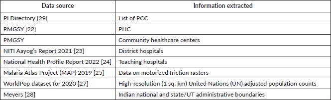
To comprehensively map the public health centres, the study necessitated the collection, extraction and collation of data from multiple data sources (Supplementary Table 1). The geolocation information for the Primary Health Centeres (PHCs) and CHCs was obtained from the Geographic Information System (GIS) dataset of the Pradhan Mantri Gram Sadak Yojana (PMGSY) [22]. The PMGSY is a fully centrally funded initiative by the Government of India aimed at providing year-round connectivity to previously inaccessible areas as part of a poverty reduction effort. We used the PMGSY GIS dataset from October 2021 to extract geo-coordinates and other relevant geographic details for the health facilities under examination, specifically the PHCs and CHCs. However, GIS data for PHCs were unavailable in 52 districts, and CHC data were missing for 90 districts. The location of DHs was extracted from the National Institute for Transforming India (NITI) Aayog’s Report on the evaluation of DHs published in 2021 [23]. Lastly, data on the location of THs were extracted from the National Health Profile Report 2022 published by the Central Bureau of Health Intelligence [24].
Access outcomes
Data on motorised friction rasters for every square kilometer were obtained from the Malaria Atlas Project 2019, an international research collaboration focusing on mapping the global response to malaria [25]. The friction rasters contain information related to the transport network in the given region and the factors that affect the time taken to move from one location to the other. Road, rail networks, navigable rivers and shipping lanes are included in the transport networks. Environmental factors, such as land cover and slope, affect the travel speed and political factors include national and state/UT boundaries that impact travel time [26].
Population projections and national and state-level borders
High-resolution (1 km2) United Nations adjusted population counts from the WorldPop dataset for 2020 for India served as our source of population data [27]. The administrative borders of India were drawn from the publicly available shapefile [28].
Outcomes
We had three primary outcomes for the situational analysis. First, we report the density of PC centres per ten million people to understand their geographic distribution relative to the regional population. Second, we report the travel time to the nearest PC centre. Using the granular estimates of travel time for each 1 km2 pixel or grid cell, we report the median and interquartile range (IQR) values at aggregate group levels. Lastly, we report the APC, which we defined as the percentage of the population with timely access to the nearest PC centre. We estimated the timely access for motorised transport and considered timely access as within 30, 60 and 120 minutes. APC combined the population and timeliness aspects of access to care.
For our secondary outcome, we report the same geographical accessibility outcomes mentioned above for different models of PC service delivery through public health centres and THs (Table 1).
Data analysis
For the geocoding of the centres, addresses were cleaned manually for improved machine readability. We used the Google Maps Application Programming Interface for geocoding. For locations that returned multiple sets of coordinates, the ones with the most relevant address string were chosen. Geo-coordinates were used to identify and remove duplicates and points extending beyond India's latitude and longitude limits. State-wise population data were extracted by imposing administrative boundaries.
For travel times, the Dijkstra algorithm was utilised to compute the minimum time required to traverse the friction surface from every pixel (grid cell) on the map to the geo-coordinates of every PC and public health centre. The algorithm was implemented for motorised transport. As walking long distances is not feasible for PC patients, we did not calculate travel time for a walking mode of transport. Lakshadweep and the Andaman & Nicobar Islands were excluded from our analysis due to methodological limitations in assessing access in regions where motorised road transport is not the primary mode of travel for healthcare access.
Access time for motorised transport was set at thresholds of 30, 60 and 120 minutes per previously published literature [30–32]. A binary accessibility raster was created with ‘1’s for pixels that fulfilled the timeliness criterion of each proxy variable and not applicable (‘NA’s) for cases otherwise. This raster was then overlaid on the population raster (extent matched). The population figures at each pixel were multiplied with the weights (i.e., ‘1’s and ‘NA’s) to get the population number with timely access.
The main analysis looked at the geographical access to PCC-PI and the secondary analysis looked at the geographical access to the centres as per the scenarios mentioned in Outcomes. Duplicates between Pallium India’s directory and the list of public health centres were removed during the analysis of the secondary outcome.
Results
Situational analysis of access to PCC-PI
PCC-PI density
The Pallium India’s directory contained 526 PCC-PI in 2022. Outpatient, inpatient and home care were provided in 410 (77.9%), 324 (61.6%) and 381 (72.4%) centres, respectively. Of the 504 centres with available data, morphine was present in 333 (66.1%) centres. At least one trained healthcare worker was present in 477 (90.7%) centres. Services were free at 371 (73%) out of 508 centres with available data and 19 (3.7%) centres provided free service to only those from poor socio-economic backgrounds. Of all centres, 44.5% centres were present in Kerala, and no centres were present in Andaman & Nicobar Islands, Dadra & Nagar Haveli, Daman & Diu and Ladakh. The PCC-PI density at the national level was four centres per ten million population. In states/UTs with PC centres, the density was the highest in Lakshadweep with 147 centres for every ten million, followed by Goa (96 centres/10 million) and Kerala (66 centres/10 million) (Table 2).
Timely access to PCC-PI
Nationally, the median (IQR) travel time to the nearest PC centre was 118 (71, 179) minutes. The median (IQR) time was longer for rural (120 (72, 180) minutes) than for urban areas (57 (16, 109) minutes).
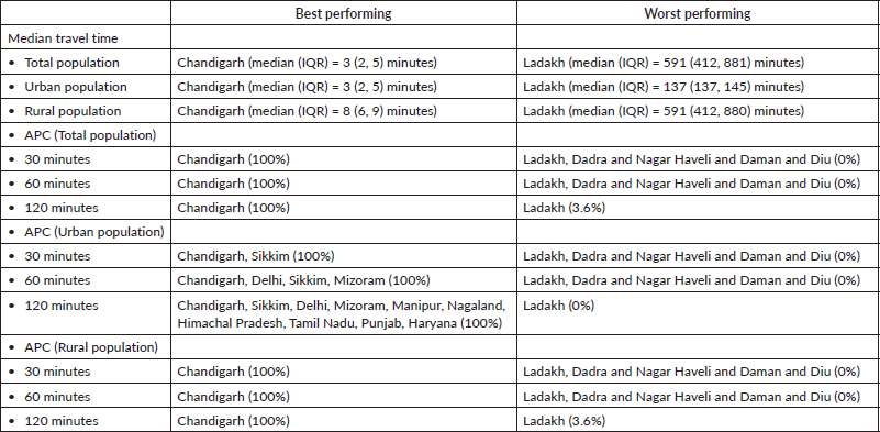
Notable differences were noticed in access to the nearest PC centre at the state/UT level. The median time to reach the nearest PCC-PI was the lowest for Chandigarh (median (IQR) = 3 (2, 5) minutes) and the highest for Ladakh (median (IQR) = 591 (412, 881) minutes) (Table 3).
Twenty-nine states/UTs had a median time longer than 30 minutes. The median travel time was worse for rural areas than for urban areas in all states/UTs (Table 3). The state/UT with the lowest rural median travel time was Chandigarh (8 (6, 9) minutes) and rural Ladakh had the highest median travel time of 591 (412, 880) minutes. Similarly, the median travel time of urban Chandigarh (3 (2, 5) minutes) was the lowest and urban Ladakh (137 (137, 145) minutes) was the highest. Compared with the national median travel time, 14 states/UTs did worse.
APC of PCC-PI
Nationally, only 23.7% of the population resided within 30 minutes, 39.9% within 60 minutes and 71% within 120 minutes of the nearest PCC-PI. The coverage of PCC-PIs was worse in rural areas with only 11.8% of the population within 30 minutes, 29.3% within 60 minutes and 65.2% within 120 minutes as compared to the urban areas, where 55.6% of the population was within 30 minutes, 68.3% within 60 minutes and 86.2% within 120 minutes of the nearest PCC-PI.
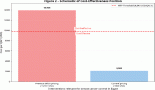
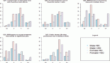
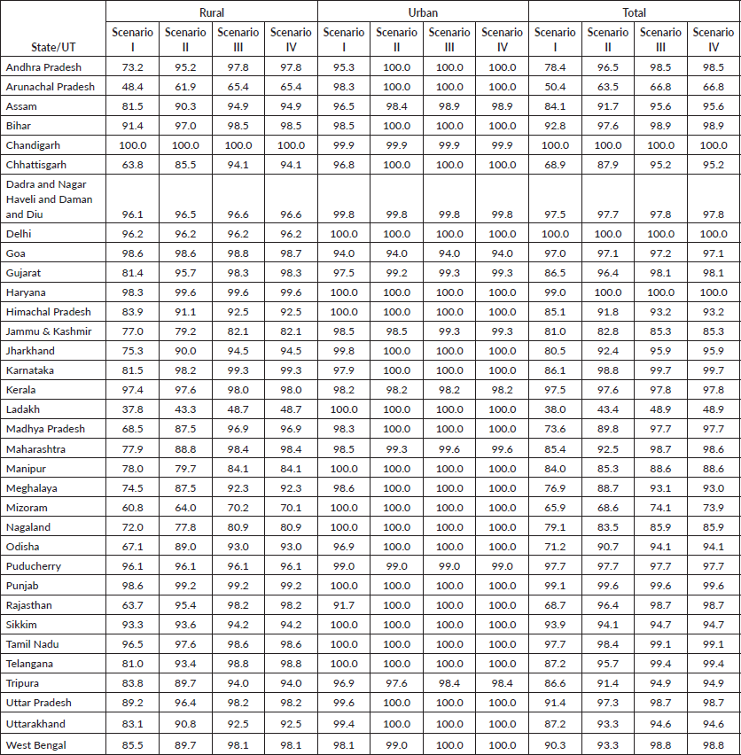
Among the states/UTs, 28, 20 and 6 states/UTs had less than 50% population within 30 minutes, 60 minutes and 120 minutes, respectively. Chandigarh, Delhi, Kerala and Goa had more than 90% of the total population within 30 minutes (Figure 1). When compared with the percentage of the population within 30 minutes at the national level, 15 states/UTs did worse. The percentage of the population with access within 30 minutes and 60 minutes was worse for rural areas as compared to urban areas in all states/UTs (Table 4). In states/UTs with at least one PC centre, Madhya Pradesh had only 3.3% of the population with access within 30 minutes as compared to Chandigarh and Kerala where 100% and 93% had access to the nearest PCC-PI within 30 minutes. Similarly, the percentage of the population with access within 30 minutes was the lowest for urban Bihar (18.8%) and the highest for urban Sikkim (100%). Rural populations of Chandigarh, Goa and Kerala had a higher percentage of the population within 30 minutes of access than urban populations of 26 states/UTs (Figure 2).
The best and worst performing states in terms of median travel times and APC are summarised in Table 5.
Scenarios of PC delivery from PCC-PI and public health centres
Scenario I (PCC-PI + THs + DHs)
Travel times: Nationally, the median (IQR) travel time to the nearest centre using a motorised vehicle was 51 (30, 82) minutes. The travel duration was longer for rural (51 (31, 83) minutes) than for urban areas (14 (4, 32) minutes).
Among state/UTs, Chandigarh had the shortest median (IQR) travel time of 3 (2–4) minutes and Arunachal Pradesh had the longest, 381 (132, 860) minutes. Travel times for rural areas were longer than for urban areas in all states/UTs (Table 6).
APC: About 54.5% of the national population resided within 30 minutes, 86.4% within 60 minutes and 98.4% within 120 minutes of their nearest centre. Rural areas had lower APC than urban areas for access within 30 minutes (42.5% versus 87.2%), 60 minutes (82.0% versus 98.4%) and 120 minutes (97.8% versus 100.0%).
Table 1. Scenarios of PC service delivery by including different levels of the public health system.
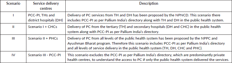
Table 2. PC centres per 10 million population in India.
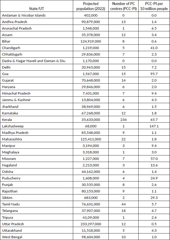
Table 3. State-wise time to reach the nearest PC centre (PCC-PI) for total, rural and urban populations.
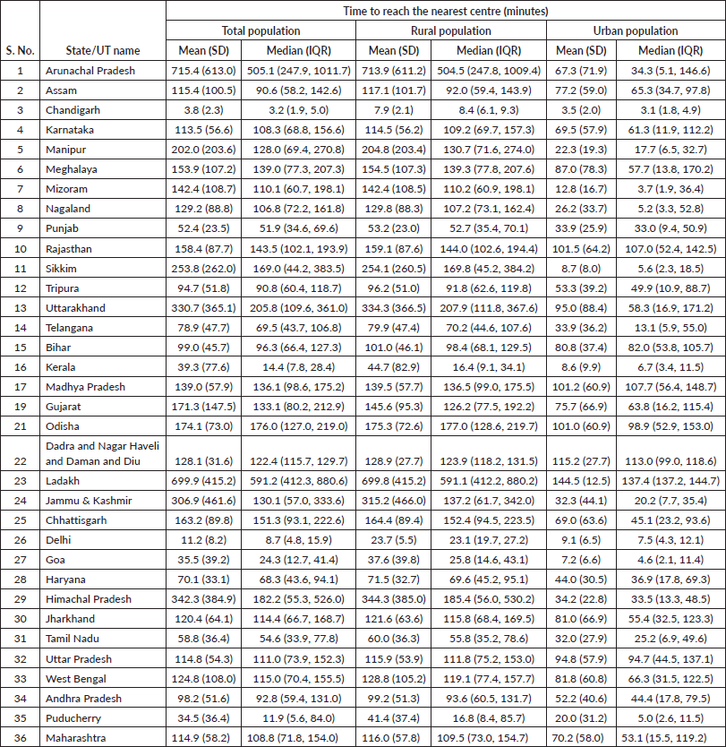
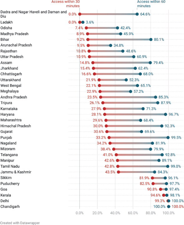
Figure 1. State-level APC of PCC-PI at 30-minute and 120-minute time thresholds.
Among state/UTs, Delhi (100%), Chandigarh (100%), Puducherry (97.7%), Kerala (95.9%), Goa (93.5%) and Dadra & Nagar Haveli and Daman & Diu (93.1%) had more than 90% of the population within 30 minutes of the nearest centre. When compared with the percentage of the population within 30 minutes at the national level, 13 states/UTs did worse. The percentage of the population within 30 minutes was worse for rural areas than for urban areas in all states/UTs (Table 7).
Table 4. APC of PCC-PI for total, rural and urban populations.
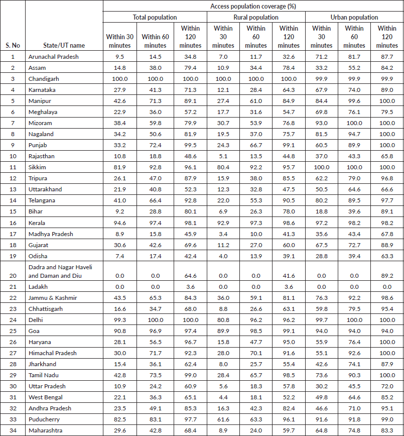
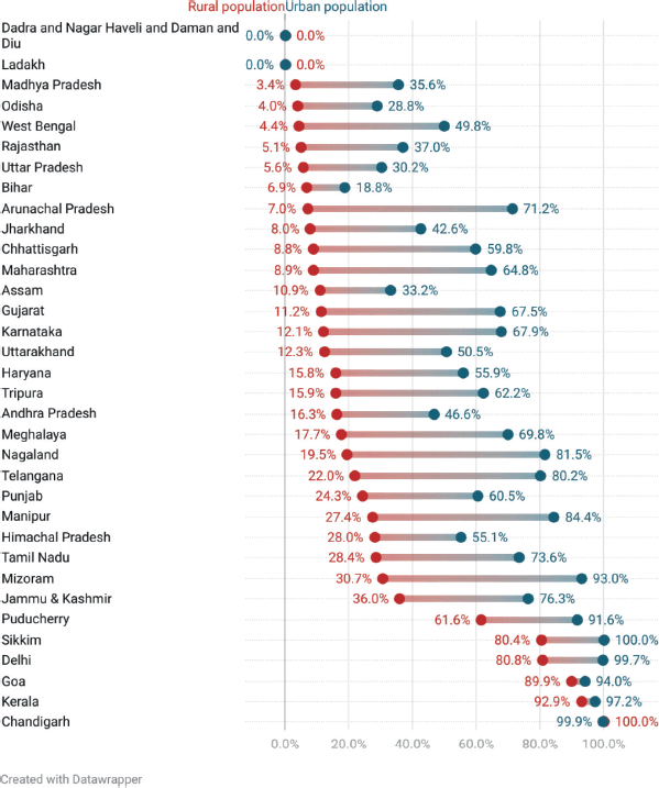
Figure 2. Rural and urban disparity in APC for PCC-PI at a 30-minute time threshold.
Scenario II (Scenario II + CHCs)
Travel times: Nationally, the median (IQR) travel time for the total population to the nearest centre was 31 (15, 54) minutes. The travel duration was longer for rural (32 (18, 56) minutes) than for urban populations (8 (3, 19) minutes).
Table 5. Best and worst performing states in terms of median travel times and APC.
Among the state/UTs, Chandigarh had the shortest median (IQR) travel time of 3 (2, 4) minutes and Ladakh had the longest time of 350 (171, 634) minutes. Travel times for rural areas were longer than for urban areas in all states/UTs (Table 6).
APC: About 76.7% of the national population resided within 30 minutes, 95.2% within 60 minutes and 99.1 within 120 minutes from the nearest centre. Rural areas had lower APC compared with urban areas for 30 minutes (69.7% versus 95.8%), 60 minutes (93.5% versus 100%) and 120 minutes (98.7% versus 100%).
Among the state/UTs, Delhi (100%), Chandigarh (100%), Puducherry (97.7%), Haryana (97.4%), Punjab (96.4%), Kerala (96.4%), Goa (93.6%) and Dadra & Nagar Haveli and Daman & Diu (93.3%) states/UTs had APC of more than 90% for 30 minutes. When compared with the APC for 30 minutes for the national population, 17 states/UTs did worse. The APC for 30 minutes was worse for rural areas as compared to urban areas in all states/UTs, except Chandigarh, where 100% of both rural and urban populations were within 30 minutes of the nearest centre (Table 7).
Scenario III (Scenario II + Primary Health Centeres)
Travel times: Nationally, the median (IQR) travel time to the nearest centre was 16 (7, 33) minutes. The travel duration was longer for rural (16 (7, 33) minutes) than for urban areas (4 (2, 8) minutes).
Among states/UTs, Chandigarh had the shortest median (IQR) travel time of 3 (1, 4) minutes, while Ladakh had the longest time of 301 (117, 515) minutes. Travel times for rural areas were longer than for urban areas in all states/UTs (Table 6).
APC: About 92.8% of the national population resided within 30 minutes, 98% within 60 minutes and 99.3% within 120 minutes of their nearest centre. Rural areas had lower APC than urban areas for 30 (90.3% versus 100%), 60 (97.3% versus 100%) and 120 minutes (99.0% versus 100%).
Table 6. State-wise median travel times for each access scenario for total, rural and urban populations.
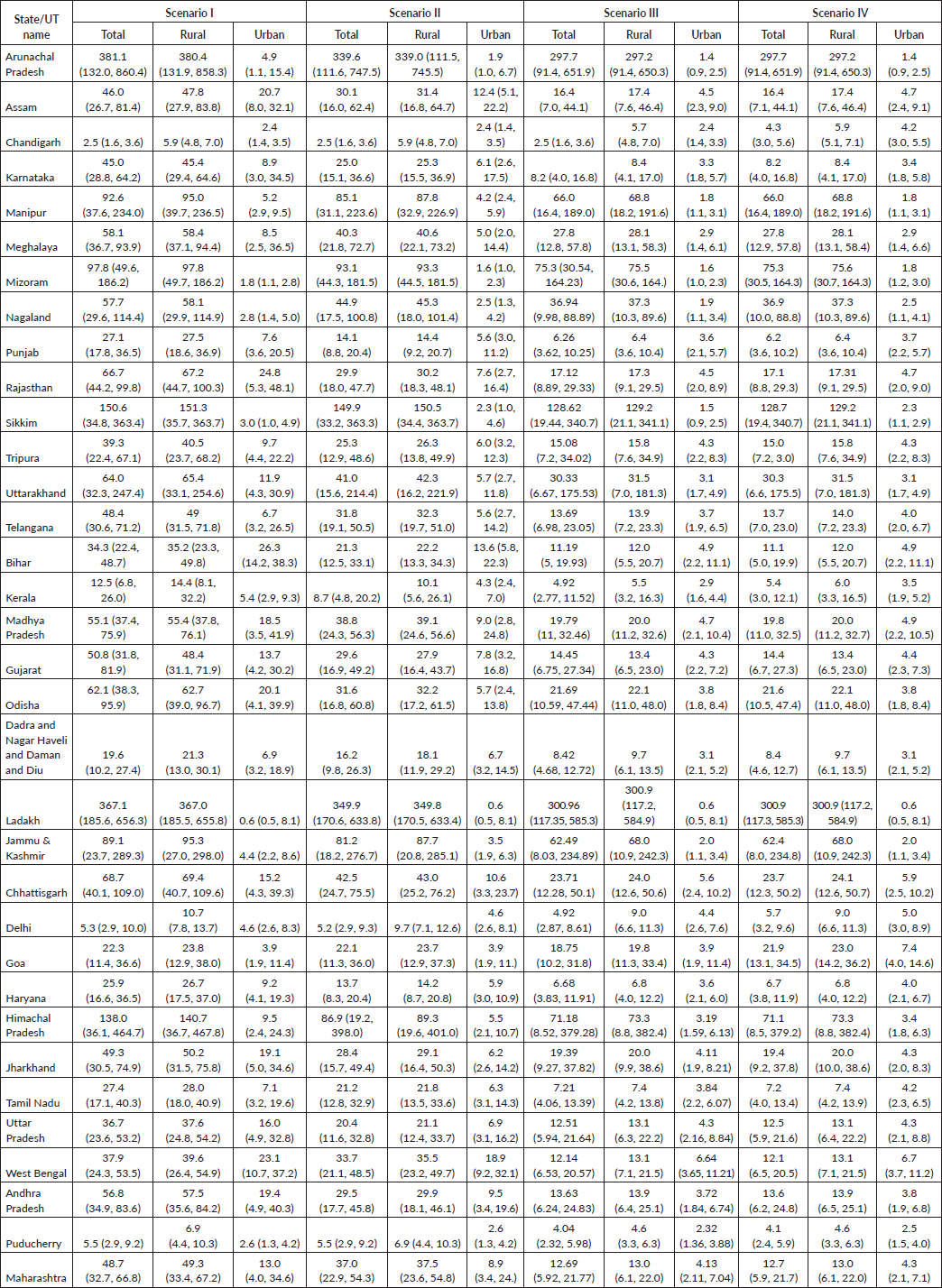
Nineteen states/UTs had over 90% of their population within 30 minutes of the nearest centre by motorised transport (Table 7). When compared with the percentage of the population covered within a 30-minute drive at the national level, 17 states/UTs did worse.
Table 7. State-wise improvement in APC for a 30-minute time threshold.

Table 8. State-wise improvement in APC for a 60-minute time threshold.
Scenario IV (Scenario III without PCC-PI)
Travel times: Nationally, the median (IQR) travel time to the nearest centre was 16 (7, 33) minutes. The travel duration was longer for rural (16 (7, 33) minutes) than for urban areas (4 (2, 8) minutes).
Among the states/UTs, Chandigarh had the shortest travel time of 3 (2, 4) minutes and Ladakh had the longest travel time of 301 (117, 585) minutes. Travel times for rural areas were worse than for urban areas in all states/UTs (Table 6).
APC: Around 92.8% of the total population resided within 30 minutes, 98.0% within 60 minutes and 99.3% within 120 minutes of the nearest centre. Rural areas had lower APC than urban areas for 30 minutes (90.3% versus 100%), 60 minutes (97.3% versus 100%) and 120 minutes (99.0% versus 100%).
Among the states/UTs, 19 states/UTs had a population of more than 90% within 30 minutes of the nearest centre (Table 7). When compared with the APC of the national population for 30 minutes, 18 states/UTs did worse.
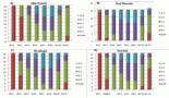
A comparison of all four scenarios revealed a progressive improvement in access in terms of time to reach the nearest centre and the APC at all time thresholds, i.e., 30, 60 and 120 minutes (Tables 7–9). Figure 3 shows heatmaps of access to PCC-PI and centres in Scenarios I–IV. The progressive reduction in area shaded ‘Red’ (highlighting region in which time taken to nearest centre would be more than one hour, i.e., APC of more than 60 minutes) visually highlights the improvement in access. At the national level, population estimates in the red zone reduced from 827,498,048 (~827 million people) in the situational analysis to 187,356,672 (~187 million), 65,889,280 (~66 million), 26,909,952 (~27 million) and 26,937,344 (~27 million) in Scenarios I–IV, respectively. When compared to the APC of PCC-PI, the APCs from scenarios I to IV were progressively improved (Figure 4). The travel times and APC of scenario III were the same or nearly similar to scenario IV, highlighting that the public health system alone could provide adequate access to PC in India.
Table 9. State-wise improvement in APC for a 120-minute time threshold.
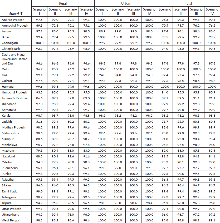
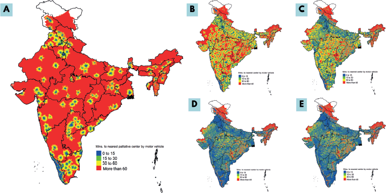
Figure 3. Heatmap showing timely access to PCC-PI (a) PCC-PI (b) Scenario I (c) Scenario II (d) Scenario III and (e) Scenario IV with the colors ‘Blue’, ‘Green’, ‘Yellow’ and ‘Red’ highlighting access within 15 minutes, 15–30 minutes, 30–60 minutes and more than 60 mintues respectively.
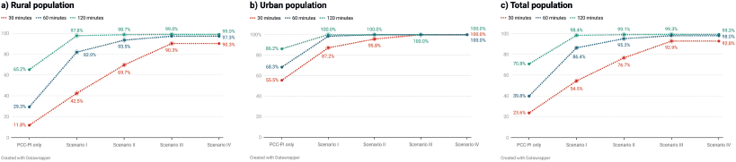
Figure 4. Improvement in APC in (a) rural (b) urban and (c) total population across different scenarios of access.
Discussion
India has only four PC centres per 10 million people. The median time to reach the nearest PC centre was nearly 2 hours, and only 23.7% of people had access to PC services within 30 minutes of motorised access. However, the coverage varies in different regions of the country. Kerala, a state in southern India, with 2.5% of the country's population, performed better than states with similar populations, like Punjab and Assam. This is because 44.5% of all the PC centres in the country were present in Kerala. This has resulted in 94.6% of the population in Kerala being within 30 minutes of the nearest PC centre, with a median (IQR) travel time to the nearest centre of 14 (8, 28) minutes. Contrary to this, the state of Uttar Pradesh, with nearly 17% of the country’s population, had only 12 (2.3%) PC centres with 10.9% of the population within 30 minutes of the nearest PC centre and a median (IQR) travel time to the nearest centre of 111 (74, 152) minutes.
Better access in the UTs of Chandigarh and Delhi and the state of Goa compared to the rest of the states/UTs can be explained by the relatively smaller size of the territories, a small population and greater urbanisation. Arunachal Pradesh, Manipur and Sikkim, states in northeast India, despite having a PC centre density better than the national average, had worse accessibility in terms of median time taken to reach the nearest centre. This can be explained by the hilly terrain of the northeastern region of the country, which would have increased the travel time to the centre.
We also noted a stark urban-rural disparity in access to PC centres. The median travel time ranged from 1 to 591 minutes in rural areas compared to 3–137 minutes in urban areas. Similarly, in states/UTs with PC centres, the APC within 30 minutes of the nearest centre ranged from 3.3% to 100% in rural areas, as compared to 18.8% to 100% in urban areas.
This can be explained by the poorer road infrastructure in rural areas, which increases travel times. In 2018–2019, the average road density in urban and rural areas was 5296.3 and 1458.1 per 1,000 km2, respectively [33]. An urban-rural disparity in the establishment of health centres has also contributed to the difference in travel times in urban and rural areas. As health professionals in India prefer to practice in urban areas, owing to the availability of better amenities and more opportunities for career growth, more centres tend to be established in urban areas [34].
In the scenarios incorporating PC at different levels of the health system, the access was noticed to be best in the third scenario, which included all the public health centres and the PCC-PI as per Pallium India’s directory. However, the access parameters were only marginally better than the scenario in which only the public health centres were included. This highlights that the public health system can effectively deliver PC in India with a supplementary role from private centres in rural and remote parts of the country where access remains poor despite complete engagement of the public health system.
A similar analysis has been attempted to understand access to PC services in high-income countries. The accessibility reported in these regions in terms of APC is significantly better than the Indian scenario. In Switzerland, Germany, Ireland, Spain and Switzerland, 95%, 86%, 84% and 79%, of the population, respectively, were reported to live within 30 minutes from the nearest centre with specialised PC services [35, 36].
While Chandigarh (100%), Delhi (99.2%), Kerala (95.7%) and Goa (92.8%) reported better access in terms of APC compared to Germany (86%), all other states/UTs in India reported access poorer than Ireland (84%). Similar to the urban-rural disparity in India, the access to PC, in terms of travel times, in rural areas of Virginia Tennessee and West Virginia in the United States of America was found to be nearly five times that the travel times in the urban areas of the respective states [37].
In this work, we have used multiple measures of geographic accessibility. Density, a commonly used metric, provides information on the geographical distribution of facilities by population. However, it fails to provide information on timely access to facilities. The presence of a road network, its quality, traffic and the availability of public or personal transport are some of the factors that impact accessibility and can be influenced by policymakers.
Our study is the first to calculate travel times and APC for PC centres in India. We preferred travel times over distances as pragmatically travel times better incorporate various infrastructural and geographical barriers mentioned previously. However, travel times fail to convey the population falling in the catchment areas of the centres. By combining time with the percentage of the population living around the centres, APC uses the percentage of the population that can access care in a given period. Therefore, APC gives us a more complete picture of the geographical accessibility to care in a region. We recommend that APC be used to guide policy regarding the establishment of future health centres in the country.
There is a need to address the disparities in geographical accessibility to PC centres through a strategic placement of new centres. This can be done by the use of location-allocation models. Using these models, policymakers can improve accessibility to centres by opening new centres at optimised locations [38]. Since patients receiving PC are home or bedbound, our analysis also shows that the existing centre-based approach to PC may not be able to universalise its access.
Therefore, policymakers need to emphasise the home-based model of PC service delivery. Through various scenarios, we also highlight how access to PC can be improved using existing public health infrastructure. Once the existing public health infrastructure is equipped with PC services, access to the ones in rural areas can be improved by improving road networks through schemes such as the PMGSY. As proposed by the NPPC, community health workers, i.e., Accredited Social Health Activists could be crucial in identifying patients requiring PC in the community and referring them to the nearest PHC or organising a visit to the patient’s house by informing the medical officer of the nearest PHC. Areas that face poor access to the nearest centre could be accessed through mobile clinics by strategically identifying nearest public health infrastructure with available services. Through these efforts, it will be possible to universalise access to PC services in India.
Limitations and strengths
The study has multiple limitations. First, this study relied only on Pallium India’s directory of PC centres and state governments or the Indian Association of PC (IAPC) were not approached to cross-check the completeness of the list. Therefore, it is possible that Pallium India’s directory missed smaller or less well-known PC facilities. This might have resulted in an underestimation of PC access. However, prior to using the directory the completeness of the directory was verified by the RFs at Pallium India to ensure the list was up to date and only active centres were included in the list. The list was also cross-checked with the directory maintained by the IAPC and Pallium India’s directory was found be larger and more up to date making it the largest available list of active centres available in India. This limitation of our study also highlights the need for state-maintained list of PC centres to ensure that not just researchers but also the public is aware of the available PC centres in their region. We have addressed this limitation by reporting changes in PC accessibility through different scenarios considering the delivery of services from different levels of the public health system. Second, our analysis inherited the assumptions and limitations of all the parent/source datasets. Third, to calculate the APC estimates, we did not take into account the access to or ownership of motor vehicles. Only 21% of Indian households owned two-wheelers, and 4.7% owned cars, jeeps or vans as per the 2011 census [39]. Although India meets WHO’s norm of 1 ambulance per 100,000 people, there are large disparities in the availability of ambulance services among states/UTs [40]. Fourth, health centre-related factors like affordability of care, functional timings, quality of services provided at the centres and the capacity of the centres to provide care were not considered while assessing accessibility.
Despite these limitations, our study has several strengths. This is the first attempt to understand access to PC in a lower-middle-income country. Considering the huge burden of non-communicable diseases in India, it becomes essential to understand the access to PC. The major strength of our study is that accessibility has been defined using three outcome measurements - PC centre density, time to reach the nearest centre and APC within multiple time frames. Not only have we reported a state-level analysis on access to PC but also done an urban-rural comparison. This will help policymakers in deciding not only how many more centres are needed in each state but also in identifying the exact locations where building a centre would improve geographic accessibility.
Conclusion
Comprehensive tools like median travel times and APC can be used to study accessibility to healthcare services. Our study found that Chandigarh, Delhi, Kerala and Goa had good access to PC while most other states/UTs, especially in the north and northeastern parts of the country need to improve accessibility to PC in the region. We also found a significant urban-rural disparity in access to PC. Future research should assess access to specific PC services like morphine availability among others and also assess accessibility for different demographic groups along with its impact on quality of life and disease outcomes. There is also a need to study access to home-based PC services either through mobile clinics or through community engagement and involvement of community healthcare workers.
List of abbreviations
APC, Access population coverage; CHC, Community Health Centres; DH, District Hospitals; GIS – Geographic Information System; IQR, Inter Quartile Range; NPNCD – National Program for Prevention and Control of Non-Communicable Diseases; NPPC – National Program for Palliative Care; PCC-PI – Active palliative care centres; PHC, Primary Health Centres; PMGSY - Pradhan Mantri Gram Sadak Yojana; RF, Regional Facilitator; TH, Teaching Hospitals; UT, Union Territories.
Conflicts of interest
The author(s) declare that they have no conflicts of interest.
Funding
This study did not receive any funding.
Data sharing statement
Data will be made available upon reasonable request to the corresponding author.
References
1. Palliative Care World Health Organization [Internet] [https://www.who.int/news-room/fact-sheets/detail/palliative-care] Date accessed: 25/12/2024
2. World Health Assembly (2014) Strengthening of Palliative Care as a Component of Comprehensive Care Throughout the Life Course [https://iris.who.int/handle/10665/162863]
3. Rashmi R and Mohanty SK (2023) Examining chronic disease onset across varying age groups of Indian adults using competing risk analysis Sci Rep 13(1) 5848 https://doi.org/10.1038/s41598-023-32861-5 PMID: 37037884 PMCID: 10086019
4. Vollset SE, Ababneh HS, and Abate YH, et al (2024) Burden of disease scenarios for 204 countries and territories, 2022–2050: a forecasting analysis for the Global Burden of Disease Study 2021 Lancet 403(10440) 2204–2256 https://doi.org/10.1016/S0140-6736(24)00685-8
5. Knaul F, Bhadelia A, and Atun R, et al (2019) Palliative care: an essential facet of universal health coverage Lancet Glob Health 7(11) e1488 https://doi.org/10.1016/S2214-109X(19)30323-7 PMID: 31607456
6. Bhatt N (2023) India faces a growing need for palliative care BMJ 382 1751 https://doi.org/10.1136/bmj.p1751 PMID: 37666532
7. Arokiasamy P (2018) India’s escalating burden of non-communicable diseases Lancet Glob Health 6(12) e1262–e1263 https://doi.org/10.1016/S2214-109X(18)30448-0 PMID: 30292427
8. Knaul FM, Farmer PE, and Krakauer EL, et al (2018) Alleviating the access abyss in palliative care and pain relief—an imperative of universal health coverage: the Lancet Commission report Lancet 391(10128) 1391–1454 https://doi.org/10.1016/S0140-6736(17)32513-8
9. Patil S, Sharma P, and Arora A, et al (2024) Unmet need for cancer palliative care in India BMJ Support Palliat Care https://doi.org/10.1136/spcare-2024-004978 PMID: 38834235
10. Agrawal US, Sarin J, and Bakhshi S, et al (2023) Challenges and opportunities in providing palliative care services to children with a life-limiting illness: a systematic review Natl Med J India 35(5) 284–289 https://doi.org/10.25259/NMJI_349_2022 PMID: 37167501
11. Directorate General of Health Services (2012) National Program for Palliative Care [Internet] [https://dghs.gov.in/content/1351_3_NationalProgramforPalliativeCare.aspx] Date accessed: 1/01/2025
12. Ministry of Health and Family Welfare, Government of India (2012) Operational Guidelines for Palliative Care at Health and Wellness Centers [https://nhsrcindia.org/sites/default/files/2021-06/Operational%20Guidelines%20for%20Palliative%20Care%20at%20HWC.pdf]
13. Ministry of Health and Family Welfare, Government of India (2023) Revised Operational Guidelines of the National Programme for Prevention and Control of Non-Communicable Diseases (2023-2030) (New Delhi: MoHFW) [https://www.mohfw.gov.in/sites/default/files/NP-NCD%20Operational%20Guidelines_0.pdf?utm_source=chatgpt.com"https://www.mohfw.gov.in/sites/default/files/NP-NCD%20Operational%20Guidelines_0.pdf] Date accessed: 25/12/24
14. Ghoshal A, Khan JA, and Spruijt O, et al (2022) Situational analysis of the quality of palliative care services across India: a cross-sectional survey ecancermedicalscience 16 1486 [https://doi.org/10.3332/ecancer.2022.1486]
15. National Medical Commission (2023) Minimum Standard Requirments for Establishment of New Medical College/Increase of Seats in MBBS Course Guidelines, 2023 [https://www.nmc.org.in/rules-regulations/national-medical-commission-minimum-standard-requirments-for-establishment-of-new-medical-college-increase-of-seats-in-mbbs-course-guidelines-2023-reg/]
16. Patel F, Sharma S, and Khosla D (2012) Palliative care in India: current progress and future needs Indian J Palliat Care 18(3) 149–154 https://doi.org/10.4103/0973-1075.105683
17. Mclaughlin CG and Wyszewianski L (2002) Access to care: remembering old lessons Health Serv Res 37(6) 1441–1443 https://doi.org/10.1111/1475-6773.12171
18. Mahajan A, Tirakotai W, and Masayaanon P (2023) The hidden costs of universal health coverage: solutions from the fight against catastrophic healthcare expenditure in Thailand BMJ Global Health 8 e011932 [https://doi.org/10.1136/bmjgh-2023-011932]
19. Harding R, Nair S, and Ekstrand M (2019) Multilevel model of stigma and barriers to cancer palliative care in India: a qualitative study BMJ Open 9(3) 24248 https://doi.org/10.1136/bmjopen-2018-024248
20. Kc S, Wurzer M, and Speringer M, et al (2018) Future population and human capital in heterogeneous India Proc Natl Acad Sci U S A 115(33) 8328–8333 https://doi.org/10.1073/pnas.1722359115 PMID: 30061391 PMCID: 6099904
21. Chokshi M, Patil B, and Khanna R, et al (2016) Health systems in India J Perinatol 36(Suppl 3) S9–S12 https://doi.org/10.1038/jp.2016.184 PMID: 27924110 PMCID: 5144115
22. National Rural Infrastructure Development Agency (NRIDA), Government of India. Pradhan Mantri Gram Sadak Yojana [Internet] [https://pmgsy.nic.in/] Date accessed: 1/01/2025
23. Sarwal R, Kalal S, and Iyer V (2025) Best practices in the performance of district hospitals. NITI Aayog OSF Preprints [https://osf.io/preprints/osf/y79bg_v1] Date accessed: 25/12/24
24. Central Bureau of Health Intelligence (CBHI), Directorate General of Health Services, Ministry of Health and Family Welfare, Government of India (2022) National Health Profile 2022 17th Issue. Central Bureau of Health Intelligence (CBHI), Directorate General of Health Services, Ministry of Health and Family Welfare, Government of India
25. The Malaria Atlas Project Explorer - Malaria Atlas Project [https://malariaatlas.org/explorer/#/] Date accessed: 1/01/2025
26. European Commission. Global Accessibility Map [https://forobs.jrc.ec.europa.eu/gam/description] Date accessed: 1/01/2025
27. School of Geography and Environmental Science, University of Southampton; Department of Geography and Geosciences, University of Louisville; Departement de Geographie, Universite de Namur, Center for International Earth Science Information Network (CIESIN), Columbia University (2018) WorldPop. 22 Jun 2020 [https://dx.doi.org/10.5258/SOTON/WP00671] Date accessed: 1/01/2025
28. Meyers J (2020) India Official Boundaries 2019 [https://github.com/justinelliotmeyers/India_Official_Boundaries_2019] Date accessed: 1/01/2025
29. Pallium India Directory of Palliative Care Services - Pallium India [Internet] [https://palliumindia.org/clinics] Date accessed: 1/01/2025
30. Schuurman N, Fiedler RS, and Grzybowski SC, et al (2006) Defining rational hospital catchments for non-urban areas based on travel-time Int J Health Geogr 5 43 https://doi.org/10.1186/1476-072X-5-43 PMID: 17018146 PMCID: 1617091
31. Gatrell AC and Wood DJ (2012) Variation in geographic access to specialist inpatient hospices in England and Wales Health Place 18(4) 832–840 https://doi.org/10.1016/j.healthplace.2012.03.009 PMID: 22522100
32. Wan N, Zou B, and Sternberg T (2011) A three-step floating catchment area method for analyzing spatial access to health services Int J Geographical Inf Sci 26(6) 1073–1089 https://doi.org/10.1080/13658816.2011.624987
33. Transport Research Wing, Ministry of Road Transport and Highways, Government of India (2022) Basic Road Statistics in India (2018–2019) [https://morth.nic.in/sites/default/files/Basic%20Road%20Statistics%20in%20India-2018-19.pdf]
34. Sabde Y, Diwan V, and Mahadik VK, et al (2020) Medical schools in India: pattern of establishment and impact on public health - a geographic information system (GIS) based exploratory study BMC Public Health 20(1) 755 https://doi.org/10.1186/s12889-020-08797-0 PMID: 32448195 PMCID: 7245906
35. Van Steijn D, Pons Izquierdo JJ, and Garralda Domezain E, et al (2021) Population’s potential accessibility to specialized palliative care services: a comparative study in three European countries Int J Environ Res Public Health 18(19) 10345 https://doi.org/10.3390/ijerph181910345 PMID: 34639645 PMCID: 8507925
36. Gesell D, Hodiamont F, and Bausewein C, et al (2023) Accessibility to specialist palliative care services in Germany: a geographical network analysis BMC Health Serv Res 23(1) 786 https://doi.org/10.1186/s12913-023-09751-7 PMID: 37488579 PMCID: 10364400
37. Svynarenko R, Huang G, and Keim-Malpass J, et al (2024) A comparison of hospice care utilization between rural and urban children in Appalachia: a geographic information systems analysis Am J Hosp Palliat Care 41(3) 288–294 https://doi.org/10.1177/10499091231173415 PMCID: 10826679
38. Rahman SU and Smith DK (2000) Use of location-allocation models in health service development planning in developing nations Eur J Oper Res 123 437–452 https://doi.org/10.1016/S0377-2217(99)00289-1
39. Ministry of Statistics and Program Implementation (2015). Motor Vehicles - Statistical Year Book India [Internet] [https://mospi.gov.in/statistical-year-book-india/2015/189] Date accessed: 1/01/2025
40. Rahman P and Mehnaz S (2024) Public policy in Bangladesh: balancing change and stability SSRN [https://ssrn.com/abstract=5048631] Date accessed: 25/12/24
Supplementary Table
Supplementary Table 1. Source of data and information extracted from each data source.